

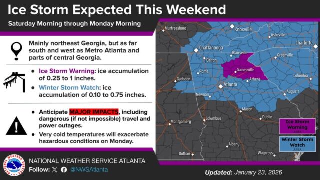
An Ice Storm Warning is now in effect for parts of northeast Georgia including Hall and surrounding counties from Saturday afternoon through Monday morning. Ice accumulations from 0.25″ to 1″ are expected, the weather service according to the weather service.
“Even just a fraction of an inch of ice has major impacts on roadways and makes travel dangerous!” the advisory says. “Ice accumulations (while less overall) are also expected across the (adjoining) Winter Storm Watch area and will lead to hazardous travel. #gawx
“Very cold temperatures will follow and (worsen) hazardous conditions on Monday.” Gainesville’s forecast low Monday night is 9 after a high of 31.
The 7-day weather service forecast for the Gainesville area:
Overnight
A 30 percent chance of showers. Cloudy, with a low around 42. East wind around 5 mph.
Friday
A 30 percent chance of showers, mainly before 7am. Cloudy, with a high near 47. Northeast wind around 5 mph.
Friday Night
Cloudy, with a low around 36. East wind around 5 mph.
Saturday
A chance of rain showers between 1pm and 4pm, then a chance of sleet after 4pm. Cloudy, with a high near 39. East wind 10 to 15 mph, with gusts as high as 25 mph. Chance of precipitation is 50%.
Saturday Night
Freezing rain, possibly mixed with sleet. Low around 27. East wind around 15 mph, with gusts as high as 25 mph. Chance of precipitation is 100%.
Sunday
Freezing rain, possibly mixed with sleet before 10am, then freezing rain between 10am and 4pm, then rain or freezing rain after 4pm. High near 33. Chance of precipitation is 100%.
Sunday Night
Rain, possibly mixed with freezing rain before 7pm, then a chance of freezing rain between 7pm and 1am. Low around 21. Chance of precipitation is 80%.
Monday
Mostly sunny, with a high near 31.
Monday Night
Mostly clear, with a low around 9.
Tuesday
Sunny, with a high near 36.
Tuesday Night
Mostly clear, with a low around 21.
Wednesday
Mostly sunny, with a high near 39.
Wednesday Night
Partly cloudy, with a low around 18.
Thursday
Sunny, with a high near 34.
To contiune reading click here.
It was originally published on this site.


