

A significant winter storm is possible across much of northern Georgia this weekend.
Coming right after the recent light snowfall in west-central Georgia, another storm system is quickly developing to our west. This system is expected to move east beginning Thursday and bring multiple rounds of precipitation to the state.
Storm setup
The first round of precipitation is expected Thursday into Friday. This initial wave should be light and fall entirely as rain across the region.
By late Friday night into early Saturday, a shallow Arctic air mass will be nearby, supported by a very strong area of high pressure over the northeastern United States.
Around midnight Friday, temperatures should remain above freezing across most areas. However, parts of the mountains and far northwest Georgia could dip below freezing early.
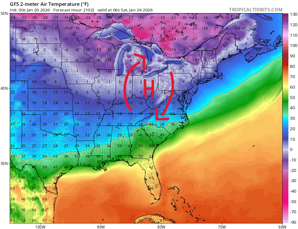
A few hours later, a strong pressure gradient between the high pressure to the north and low pressure to the south is expected to drive cold air rapidly southwestward. In a classic “wedge” setup, the Appalachians will funnel this cold air out of the northeast and into Northeast Georgia through the day Saturday.
By Saturday afternoon, surface temperatures are expected to be below freezing across a wide area, and in many locations, well below freezing.
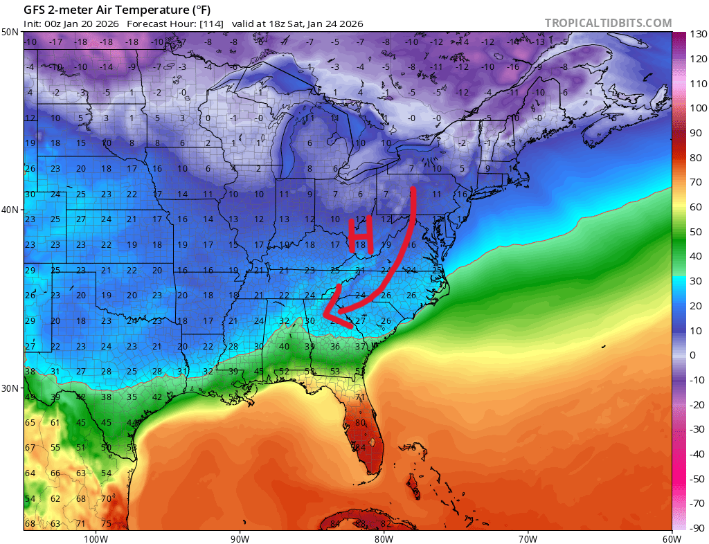
In many Southern winter storms, strong south winds ahead of the low pressure system are able to erode the cold air and keep precipitation as cold rain. That is the most common outcome. However, current forecast models do not show that scenario this time. Instead, guidance points to a generally weak low pressure system.
Abundant moisture will move north and ride over the cold air at the surface. This overrunning pattern will create enough lift for widespread, long-lasting precipitation from Saturday into Sunday.
What to expect
The key question over the next few days will be where the transition zones set up.
SNOW VS. EVERYTHING ELSE:
There is a chance the mountains could see a brief period of accumulating snow at the start of the storm, and possibly again overnight Saturday. However, any snow is expected to be short-lived, with a rapid transition to the next phase.
SLEET VS. FREEZING RAIN:
This will be the most important and impactful boundary of the storm. The depth of the cold air will be critical, and this is something lower-resolution global models, typically used 4 to 5 days out, struggle to handle accurately.
Based on current data, a fairly large swath of sleet is possible from the South Carolina border southwest toward the Atlanta area.
By Saturday night, the cold air should be relatively deep by wedge standards. That depth may be enough to keep precipitation falling as sleet, or possibly a sleet-snow mix, across much of Northeast Georgia. Where the sleet changes to freezing rain will likely be where the most severe impacts occur.
There is a high likelihood that this storm will produce a significant ice event somewhere in the region.
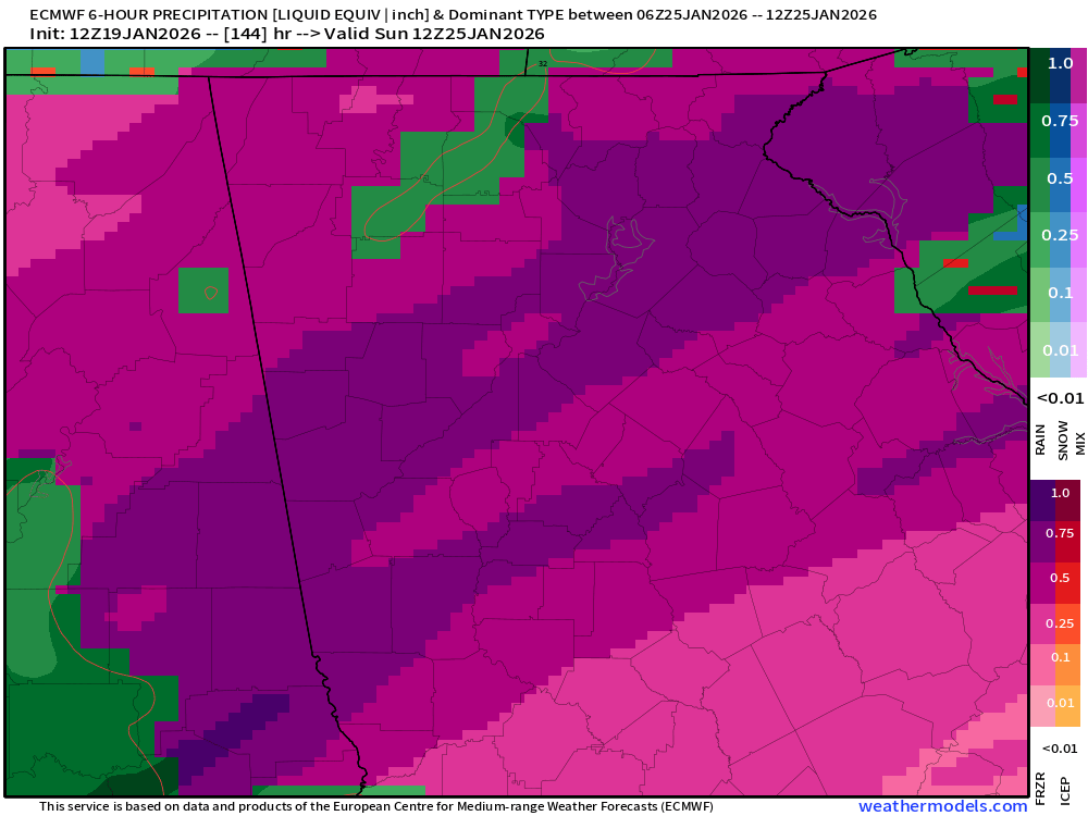
This sleet-freezing rain boundary is expected to shift back and forth during the storm. The image below from the Euro model shows potential 6-hour accumulations of freezing rain early Sunday morning. To say this would be catastrophic for some locations would not be an understatement.
That said, global models often underestimate how deep the cold air becomes. Because of that, not all precipitation currently shown as freezing rain would necessarily fall that way.
FREEZING RAIN VS. COLD RAIN:
The final transition zone will be between freezing rain and plain cold rain. This line is expected to move southwest through the day and overnight Saturday, potentially reaching as far west as eastern Alabama and the northern parts of South Georgia. We’ll be monitoring this area closely as well as the system draws closer.
Bottom line
This system has the potential to be a high-impact winter storm across North Georgia beginning late Friday night. Now is the time to make sure you have any emergency equipment, like generators and chainsaws, ready to go.
As we saw with the storm over the weekend, things can change on a dime, but right now, all signs point towards a problematic weekend.


